Overview
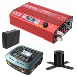
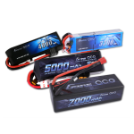
The Mavic 2 Car Charger has a maximum output power of 80W, allowing you to charge batteries while driving. It features overheating protectio..
Monitor Mount PRO for Inspire This is a CNC machined, aluminum mount that allows you to mount any 1/4-20 monitor on to your Inpire transmitter. Use it..
Fusion Upgrade
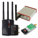
Amimon Connex Fusion allows the UAV operator a much more flexible choice between size and weight to multisystem enviroment.You can conn..
Mio Damping is designed to match perfectly with the Mio gimbal and its payload where 8 silicone-filled rubber balls are used to further remove high-fr..
Adicam Ball Mount System 75mm/100mm
This set is made of aluminum which ensures high durability, stability and exceptional lightness. It is suitable fo..
Connect your IR-LOCK Sensor to the Cube autopilot. This cable provides I2C communication from IR-LOCK to the Cube via the Carrier Board, and also powe..
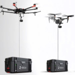
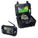
MÅVI Dock
The compact, quick-folding MÅVI Dock allows MÅVI operators to keep their setup powered on while docking on a C-Stand. What"s more, users ..
The most advanced 5.8GHz Video Transmitter available today. Only 4 grams, and a slender 31 x 20mm, the TrampHV is also the smallest direct LiPo-powere..
Connect the communication ports on the Focus Remote Controller and the Osmo - X5 Adapter using the DJI Focus - Osmo Pro/RAW Adaptor Cable. Then, you c..
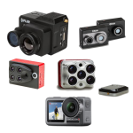
1-Inch Large CMOS CameraWith a 50MP 1-inch CMOS sensor and f/1.8 aperture, Mini 5 Pro captures rich details and clean low-light shots. Compact in size..
Lightweight & Versatile, Compact Storage [1]The 11g [8] transmitter is ultralight and stylish with colorful covers [9]. The standard case (2 TX + 1 RX..
Lightweight & Versatile, Compact Storage [1]The 11g [8] transmitter is ultralight and stylish with colorful covers [9]. The standard case (2 TX + 1 RX..
Lightweight & Versatile, Compact Storage [1]The 11g [8] transmitter is ultralight and stylish with colorful covers [9]. The standard case (2 TX + 1 RX..
Lightweight & Versatile, Compact Storage [1]The 11g [8] transmitter is ultralight and stylish with colorful covers [9]. The standard case (2 TX + 1 RX..
Stunning Visuals in Every FrameWith a 1/1.3-inch CMOS sensor and f/1.7 aperture, Lito X1 captures rich daytime details and clean nightscapes.Pack Ligh..
Stunning Visuals in Every FrameWith a 1/1.3-inch CMOS sensor and f/1.7 aperture, Lito X1 captures rich daytime details and clean nightscapes.Pack Ligh..
Stunning Visuals in Every FrameWith a 1/1.3-inch CMOS sensor and f/1.7 aperture, Lito X1 captures rich daytime details and clean nightscapes.Pack Ligh..
Stunning Visuals in Every FrameWith a 1/1.3-inch CMOS sensor and f/1.7 aperture, Lito X1 captures rich daytime details and clean nightscapes.Pack Ligh..
8K Photos [4], Rich in DetailWith a 1/2-inch CMOS sensor, DJI Lito 1 captures up to 8K photos [4]. From action moments to serene landscapes, it preser..
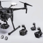
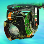
A Lidar + RGB Solution for Aerial Surveying The Zenmuse L1 integrates a Livox Lidar module, a high-accuracy IMU, and a camera with a 1-inch CMOS on a 3-axis stabilized gimbal. When used with Matrice 300 RTK and DJI Terra, the L1 forms a complete solution that gives you real-time 3D data throughout the day, efficiently capturing the details of complex structures and delivering highly accurate reconstructed models.
Integrates a Lidar module, an RGB camera, and a high-accuracy IMU
High Efficiency 2 km2 covered in a single flight
High Accuracy Vertical Accuracy: 5 cm / Horizontal Accuracy: 10 cm
Point Rate: 240,000 pts/s
Supports 3 Returns
Detection Range: 450 m (80% reflectivity, 0 klx)
IP44 Ingress Protection Level
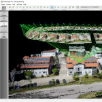
Point Cloud LiveView
Digitize without Compromise
Exceptional Efficiency Generate true-color point cloud models in real-time, or acquire 2 km2 of point cloud data in a single flight [1] using the Livox frame Lidar module with a 70° FOV and a visible light camera with a 1-inch sensor.
Unparalleled Accuracy Render centimeter-accurate reconstructions thanks to the high-accuracy IMU, a vision sensor for positioning accuracy, and the incorporation of GNSS data.
Ready When You Are The IP44 rating allows the L1 to be operated in rainy or foggy environments. The Lidar module’s active scanning method enables you to fly at night.
Visualize Data as You Fly Livox Lidar Module
Frame Lidar with up to 100% effective point cloud results
Accurate Details at Your Disposal High-accuracy IMU
Accuracy: 0.025° (roll/pitch) / 0.08° (yaw)
Vision Sensor for Positioning Accuracy
GNSS, IMU, RGB Data Fusion
Recreate the World in 3D Point Clouds
Point Cloud LiveView Real-time point clouds provide immediate insights onsite, so operators are informed to make critical decisions quickly. You can also verify fieldwork quality by checking point cloud data immediately after each flight.
Measurement and Annotation Acquire and communicate critical dimensions on the point cloud model using measurements and annotations.
One-stop Post-processing DJI Terra fuses the IMU and GNSS data for point cloud and visible light calculations, in addition to conducting POS data calculations so you can effortlessly generate reconstructed models and accuracy reports.
Application Scenarios
Topographic Mapping Quickly generate topographic maps using accurate digital elevation models.
AEC and Surveying Manage the full project lifecycle using highly accurate point clouds and 3D models.
Emergency Response Any time of the day, gather critical insights in real-time using true-color point clouds.
Law Enforcement Gain situational awareness and forensic intel in real-time to make informed decisions on site.
Energy and Infrastructure Model sparse or complex structures in detail to manage them efficiently and safely.
Agriculture and Forestry Management Gain insight into vegetation density, area, stock volume, canopy width, and growth trends.
Find the product you want and add it to your cart. A window will open, offering you two options - to continue shopping or to complete the purchase. Choose what suits you.
When you have selected everything you need, carefully examine the basket, then click on the "continue to enter information" button. Choose from the options: natural or legal person. First, you will need to enter information, depending on whether you are a natural person or a company. If you are ordering or buying as a legal entity, i.e. a company registered in Slovenia as well as the EU, you must enter the following:
Company name
The exact address of the company
tax number
Mandatory phone number (delivery service)
Choose a payment method:
In summary
TRR
Paypal
Leanpay
At the very end, carefully read the information about your order and confirm your choice.
The package will arrive at your address within 1-3 working days.
Products are delivered by the GLS delivery service. Upon delivery, the delivery man of the GLS delivery service will call you and arrange with you to pick up the package. The package will be delivered to the address you specified when ordering.
You can choose between three payment methods:
Via the online bank or according to the estimate
PayPal*
Cash on delivery
Lean pay
If the value of the package is less than €50, delivery within Slovenia via the delivery service is €5.90. For purchases over €50, delivery within Slovenia is free.
The delivery amount is calculated at the end of the purchase.
Unfortunately, discounts and benefits in our online store do not add up. You can only use one discount code per order.
If you want to go through the return process, we kindly ask you to fill out the form here.
If, within 15 days of purchase, the customer finds that he does not want the product for any reason, he must bring the product to us in its original packaging, undamaged, UNACTIVATED with the invoice. In such a case, we return the purchase price to the customer.
If within 15 days of purchase the customer finds that there is something wrong with the product (drone), bring the product to us or you return it in the original packaging with all the contents that were in it. In such a case, we replace the customer's drone with a new one. The product can be returned in its original packaging, undamaged, with a receipt.
After 15 days, the warranty process expires. We send the product to a DJI authorized official service center. We receive the replaced product within 7-10 working days.
The warranty starts from the activation of the drone and not from the purchase of it. You do not need an account to claim the warranty.
Service at an authorized DJI drone service center takes 7-10 working days. Because DJI has high safety standards, they exchange drones for new ones and do not repair them.
Yes, you can visit our store, where we will be happy to help you and present the product.
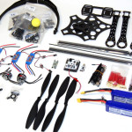
DJI Matrice M350 RTKAn upgraded flagship drone platform, the Matrice 350 RTK sets a new benchmark for the industry. This next-generation drone platfor..
DJI Matrice 350 - BS65 Battery Station
The battery station is a one-stop solution for battery charging, storage, and transport. The new Storage Mode a..


-150x150h.jpg)
-1000x1000-150x150.jpg)


-150x150.png)


")
")
![DJI Mini 3 Pro [image]](https://www.onedrone.com/store/image/cache/catalog/banners/dji_mini_3_pro_no_rc_-550x550w-200x120w.jpg)
")


")
")
")
")
")
")

")


