


")
")
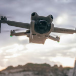
![DJI Mini 3 Pro [image]](https://www.onedrone.com/store/image/cache/catalog/banners/dji_mini_3_pro_no_rc_-550x550w-200x120w.jpg)
")


")
")
")
")
")
")

")
-150x150h.jpg)
-1000x1000-150x150.jpg)


-150x150.png)

")
Brand: DJI
Model: DJI-RS3-LRF
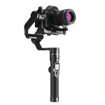
DJI LiDAR Range Finder (RS)
OverviewThe LiDAR focusing system makes focusing easier for hand-held shooting, without relying on the surface texture of the subject. This is especially useful in low-light environments and results in exceptional focusing capabilities.The new LiDAR Range Finder (RS) can ..
588.90€ (From 15.66€ monthly)
Ex Tax:482.70€

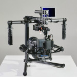
Brand: DJI
Model: DJI-RO4D-6KC
• Highly Integrated Modular Design• Full-Frame Gimbal Camera• 6K/60fps and 4K/120fps Internal RAW Recording• 4-Axis Active Stabilization• LiDAR Focusing• Wireless Transmission and Control System
Integrated and Modular Design, Ready to UseDJI Ronin 4D integrates cinematic imaging, a 4-axis gimbal, L..
6,655.90€
Ex Tax:5,455.66€

Brand: DJI
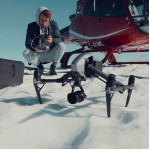
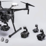
Model: DJI-M300-L1
Zenmuse L1 - Instant Clarity. Superior Accuracy.
A Lidar + RGB Solution for Aerial SurveyingThe Zenmuse L1 integrates a Livox Lidar module, a high-accuracy IMU, and a camera with a 1-inch CMOS on a 3-axis stabilized gimbal. When used with Matrice 300 RTK and DJI Terra, the L1 forms a complete soluti..
8,479.90€
Ex Tax:6,950.74€


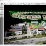
Brand: YellowScan
Model: XS-Sur-Ult
YellowScan Surveyor Ultra is a Hesai XT32M2X-based UAV LiDAR system.The YellowScan Surveyor Ultra LiDAR system is suited for high speed UAV (VTOL fixed-wing or helicopter) and long-range needs due to its high-density specifications.With the 360° Field of View of the Hesai XT32M2X laser sca..
0.00€
Ex Tax:0.00€


Brand: YellowScan
Model: YS-fly-dri
Designed to be easily swapped in minutes from vehicles to UAV.The YellowScan Fly&Drive is a versatile land vehicle-mounted or UAV-mounted mobile mapping system which combines high resolution laser scanning and precise positioning to collect geo-referenced point clouds for a wide range of applica..
0.00€
Ex Tax:0.00€


Brand: YellowScan
Model: YS-VX15-100
100kHz200kHz over 360°200kHz over 180°300kHzShots per second100k over 360°200k over 360°100k over 180°100k over 120°Scanner field of view360°360°180°120°Operating Flight Altitude AGLnatural targets > 20%100m85m100m100mAverage point density@50m AGL, 5m/s, 90° FOV50pts/sqm100pts/sqm100pts/sqm150pts..
0.00€
Ex Tax:0.00€
Brand: YellowScan
Model: YS-VX15-100
Shots per second100k over 360°Scanner field of view360°Operating Flight Altitude AGLnatural targets > 20%100mAverage point density@50m AGL, 5m/s, 90° FOV50pts/sqm..
0.00€
Ex Tax:0.00€


Brand: YellowScan
Model: YS-VX20-300
General characteristicsVx20-300 100kHz200kHz over 360°200kHz over 180°300kHzShots per second100k over 360°200k over 360°100k over 180°100k over 120°Scanner field of view360°360°180°120°Operating Flight Altitude AGL natural targets > 20%100m85m100m100mAverage point density @50m AGL,..
0.00€
Ex Tax:0.00€
Brand: YellowScan
Model: YS-VX20-100
General characteristicsVx20-100 100kHZShots per second100k over 360°Scanner field of view360°Operating Flight Altitude AGL natural targets > 20%100mAverage point density @50m AGL, 5m/s, 90° FOV50pts/sqm..
0.00€
Ex Tax:0.00€


Brand: YellowScan
Model: YS-map+
Solution presentationThe new YellowScan Mapper+ can be mounted on a wide range of UAV platforms due to its low weight.The YellowScan Mapper+ integrates the Livox AVIA laser scanner with a high performance GNSS-aided inertial navigation system into a lightweight, standalone and easy-to-use lidar syst..
0.00€
Ex Tax:0.00€


Brand: YellowScan
Model: YS-Exp
Solution presentationThe new YellowScan Explorer can be mounted on a light manned aircraft or switched to different types of UAV platforms.The YellowScan Explorer is the first LiDAR that can be mounted on a light manned aircraft or helicopter and be switched to a UAV platform like the DJI M300. This..
0.00€
Ex Tax:0.00€